


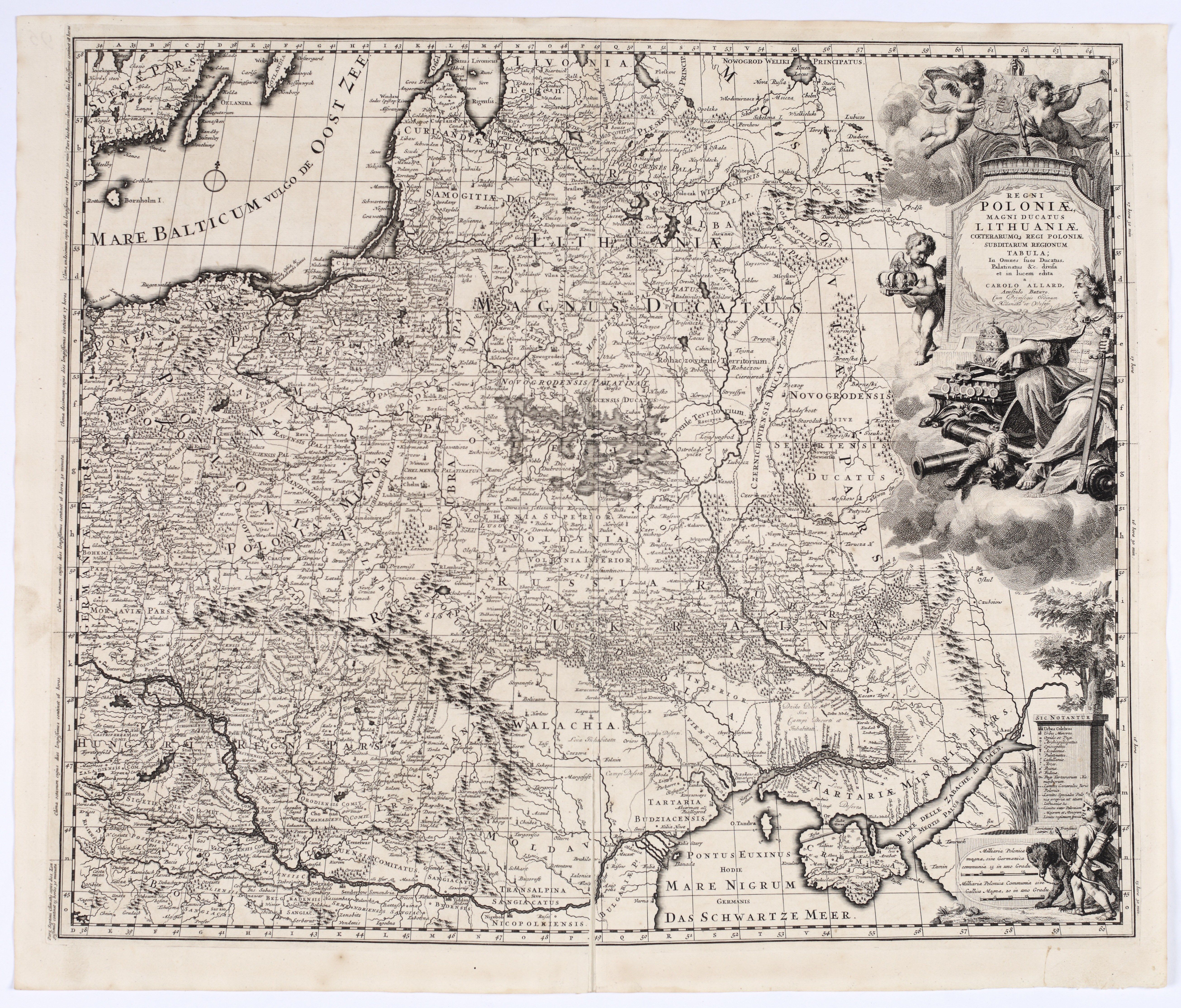
ALLARD, Carel (1648–1709) — Regni Poloniae, Magni Ducatus Lithuaniae ... Tabula. Amsterdam: ca. 1697.
Copperplate engraving, paper, 495 × 590 mm, on a sheet measuring 535 × 633 mm. Verso blank. Traces of atlas folding; minor spots and creases; inventory number written on the reverse.
The map covers the entire territory of the Polish-Lithuanian Commonwealth, depicted with exceptional detail. Its scope extends from the Baltic Sea in the north—including the islands of Gotland, Öland, and Bornholm visible in the upper left corner, through Prussia, Pomerania, Greater Poland, and Lesser Poland, Lithuania, Volhynia, and Podolia in the south, all the way to Wallachia, Moldavia, the Crimean Khanate and the Black Sea, and in the east to Smolensk, Ukraine, and the Sea of Azov.
The large allegorical title cartouche in the upper right corner was engraved by G. van Gouwen based on a design by Ph. Tideman. It depicts a crowned female personification of Poland, seated on clouds, surrounded by a crown, the royal apple, a scepter, coins, and war trophies. Cherubs hold the royal coat of arms and the crown, and above them, the winged figure of Fame blows a trumpet. The title is placed on the pedestal below. A second decorative scene in the lower right corner depicts a Tatar or Cossack archer with a bow and quiver, leading a bear on a leash. Next to it is a table explaining the symbols used on the map and the distance scales.
Carel Allard was the most prominent member of a family of cartographers, engravers, and publishers active in Amsterdam during the second half of the 17th century and the early 18th century. His father, Hugo (or Huych) Allard (c. 1625–1691), also published a map of Poland based on Guillaume Le Vasseur de Beauplan’s *Nova totius Regni Poloniae descriptio*. Carel’s map is a significantly expanded and more detailed version of Beauplan’s influential map, enriched with numerous additions and corrections drawn from later 17th-century sources.
The map was published shortly after Frederick Augustus, Elector of Saxony, ascended the Polish throne; in 1697, he became King of Poland as Augustus II. The elaborate allegorical cartouche alludes to his conversion to Catholicism, while the depicted royal regalia, war trophies, and personifications of Fame and Poland emphasize the political dimension of the composition. For another map published by the Allard family, see Item 31.
One of the most beautiful old maps of Poland.
Imago Poloniae H27/1.










Последно разглеждани позиции
Влезте, за да се запознаете със списъка с артикулите
Любими
Влезте, за да се запознаете със списъка с артикулите